
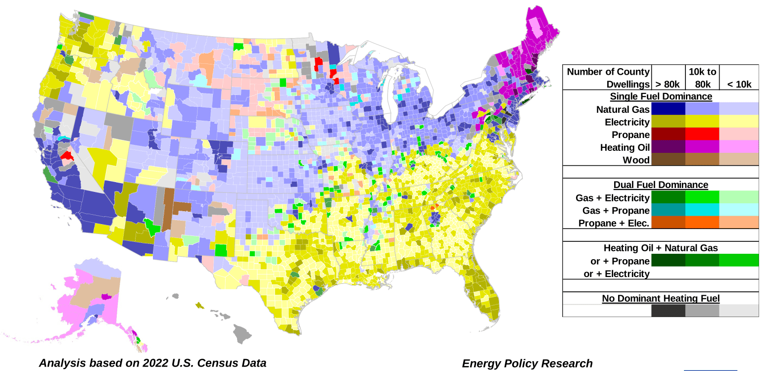
The map plots residential heating by dominant fuel source across the fifty states and the District of Columbia, drawing on 2022 U.S. Census Bureau county-level data. In all, it covers over 125 million dwellings in 3,150 counties or county-equivalent entities (parishes in Louisiana, and in some cases independent cities such as St. Louis, Missouri), ranging in size from 31 to over 3,340,000 dwellings. Each county is color-coded by both its number of dwellings and its dominant heating energy source, with premises grouped into three size categories: more than 80,000 dwellings, between 10,000 and 80,000, and fewer than 10,000.
Clear regional patterns emerge. Across most of the six New England states, heating oil is the dominant fuel. Electricity prevails in the northwestern states of Oregon and Washington and across a southeastern band running from the Atlantic Coast through most of Texas. Natural gas dominates a parallel band stretching from western Pennsylvania and New York State to the western counties of Utah, and it is the primary fuel in major urban areas including New York City, Los Angeles, San Francisco, Chicago, St. Louis, Minneapolis-St. Paul, and Atlanta. In sparsely populated rural counties such as those in the Dakotas and Arizona, where pipelines and transmission lines are not cost-effective, wood and propane are the primary fuels.
The classification rests on defined thresholds. A source is shown as dominant if more than 40% of dwellings rely on it and every other fuel accounts for less than 40%; Kern County, California, for example, has over 274,000 units, 61% of them heated by natural gas. A county is treated as dual-fuel dominant when two sources each supply between 40% and 50% and together cover at least 80% of winter heating—as in Benton County, Arkansas, with 101,109 dwellings, 46.9% heated by natural gas and 42.1% by electricity. A special case covers counties where heating oil and one other source together exceed 80%.
A small number of counties, mostly rural, have no dominant heating source. In Sanders County, Montana, for instance, of 5,390 dwellings, wood heats 35.3%, propane 33.2%, and electricity 22.7%. Taken together, the map illustrates the density, variability, and geographic patterns of the energy sources used to heat American homes.
From the EPRINC Chart of the Week archive.
Cite: EPRINC, “U.S. Residential Heating by County,” Chart of the Week 2024-04, January 22, 2024.